Skip Navigation Links
 Listings
 Introduction
 Q & A

Skip Navigation Links
 Property Search
 County GIS

Skip Navigation Links
 Township & Range 
 Texas Land Survey
 Excel To KML
 Coordinate Grids
 Polygon Area
 State Plane
 Convert Coordinates
 Batch Convert

Skip Navigation Links
 Around Town
 Forum  NEW 
 Blog
 Press
 About


Texas

Texas Land Survey on Google Earth.
more...

State Plane

State Plane coordinate system for the United States is supported.

Read the blog article for more...

Share your story with Google

Interesting project? Google wants to hear about it!
more...

New Movie

I made a short video highlighting a few real estate features of Earth Point. It is a bit rough, but please enjoy.
more...

Township and Range - Public Land Survey System on Google Earth.

A user account is recommended for one feature on this web page. 

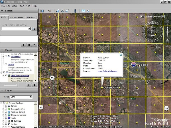
Click for larger image.
This page maps the United States Public Land Survey System onto Google Earth.  For more information about the land survey, Wikipedia has a good article.  You can read about locating parcels at Earth Point Blog.

There are two data sets to choose from, "BLM" and "National Atlas".

BLM Township, Range, and Section

Displays townships, sections, and quarter-quarter sections if you zoom in close enough (most, but not all areas have quarter-quarter sections mapped).  Calcuates area, centroid, and corner points.  You must zoom into the central or western United States to see the data.

New: Options...     (hide/show icons, labels, quarter/quarters; change colors)
  Enhanced feature.  What is this?
You are not signed in to your account. For unrestricted access, please sign in or purchase a subscription. You must have Google Earth installed to use this data.

States with complete BLM coverage
Alaska, Arizona, California, Colorado, Idaho, Montana, Nevada, New Mexico, Oregon, Utah, Washington, Wyoming

States with limited BLM coverage
Alabama, Arkansas, Florida, Illinois, Indiana, Kansas, Michigan, Minnesota, Mississippi, Missouri, North Dakota (central and western portions are covered), Ohio, Oklahoma, South Dakota (western part is covered)


Convert Township, Range, and Section to Latitude and Longitude

Enter Township and Range.  Optionally enter Section.  Google Earth flys you there using BLM data.  Hint: pause for a moment after choosing each of the criteria.  This allows the data to be loaded into the drop-down boxes.

State
Principal Meridian
Township
Range
Section

Free. User account is not needed.
If you want to see the surrounding townships, then once you have clicked the "Fly To" button, come back and click the BLM or National Atlas "View on Google Earth" button. Free. User account is not needed.

Convert Latitude and Longitude to Township and Section

Enter latitude and longitude.  Find the corresponding township and section.  The BLM database is searched first.  If nothing is found then the National Atlas database is searched.  Note that the National Atlas database has only townships, no sections.

Latitude Examples:  43°38'19.39"N,  43 38 19.39,  43.6387194
Longitude Examples:  116°14'28.86"W,  116 14 28.86,  -116.2413513

Free. User account is not needed.
If you want to see the surrounding townships, then once you have clicked the "Fly To" button, come back and click the BLM or National Atlas "View on Google Earth" button. Free. User account is not needed.

National Atlas Township and Range

Full coverage of the United States Public Land Survey.  Good alternate if there is a gap in the BLM data, but with less accuracy.  Townships only, does not have sections or quarter-quarter sections.  Calcuates area, centroid, and corner points.  You must zoom into the central or western United States to see the data.

When making a screen shot, it might be helpful to hide the icons. Be sure to include the trademarks displayed at the bottom of the screen in any published material.
 
Click just once. The screen is updated as you move around in Google Earth. Free. User account is not needed.

Hint

In mountainous areas it might be helpful to turn off the terrain layer in Google Earth.  Otherwise, the survey grid can look distorted as it shapes itself to the earth's surface.

Information: BLM Township and Range

The Bureau of Land Management (BLM) cadastral survey program is responsible for the official boundary surveys for all federal agencies in the U.S. that together manage over 700 million acres. The Public Land Survey System also called the Rectangular Survey System is the foundation for many survey-based land information systems.

Link - http://www.geocommunicator.gov/GeoComm/lsis_home/home/index.shtm

BLM DISCLAIMER:
The geographic coordinates and their associated products are NOT legal land survey records. These coordinates can NOT be used as a substitute for a legal land survey. They can be used for record keeping, mapping, graphics and planning purposes only. No warranty is made by the Bureau of Land Management for use of the data for purposes not intended by BLM.

Information: National Atlas Township and Range

This data set portrays the Public Land Surveys of the United States, including areas of private survey, Donation Land Claims, and Land Grants and Civil Colonies. This is a revised version of the May, 2002 data set.

U.S. Geological Survey, 200301, Public Land Survey System of the United States: U.S. Geological Survey, Reston, VA.

Link - http://nationalatlas.gov/atlasftp.html
FAQ - http://www.nationalatlas.gov/metadata/plss00p020.faq.html

National Atlas DISCLAIMER:
These data are intended for geographic display and analysis at the national level, and for large regional areas. The data should be displayed and analyzed at Factors appropriate for 1:2,000,000-Factor data. No responsibility is assumed by the U.S. Geological Survey in the use of these data.